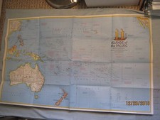
1953 Kenmare River Ireland South Coast Nautical Map - Vintage Marine Chart
This vintage 1953 nautical map of Kenmare River on Ireland’s South Coast is a collectible marine boating chart for coastal navigation history and map collectors. The item shows wear from use and storage, consistent with age and prior handling. Please review the listing photos and details to confirm exact coverage, scale, markings, and any folds, tears, or writing, as specifics are not provided here. Ships with free shipping, and it will be packed to help protect it during transit. Check the listing for details.


| Location | Sarasota US |
| Shipping | Free shipping (check listing for details) |
| Seller |
theresalestoreinc
99.9% positive · 11165 feedback
|
| Listing | FixedPrice · Active |
| Start time | 2025-11-02T00:58:05.000Z |
Vintage 1953 Kenmare River Ireland South Coast Nautical Marine Boating MapHas wear from use and storage43.5" x 29.75"Communication is KEY! If there are any issues or questions PLEASE contact us through EBAY messaging so they can promptly be handled.Please carefully review our detailed pictures, title and description before purchasing. Most items are shipped out the same or next day. Please let us know of any shipping needs that you do not see offered and we will do our best to accommodate. Flat rate shipping is figured for the lower 48.Please wait for an updated invoice before paying for combined shipping.We do offer local pickup for your convenience on the Gulf Coast of Florida