Chez Vignon Linen Folding Map of Nancy, France (c.1790) Antique
This antique linen folding map depicts Nancy, France and is attributed to Chez Vignon, dating to around 1790. It is listed in the Antiques category and offered with free shipping. The exact condition is not provided here; check the listing for details on wear, folds, staining, repairs, or any missing sections typical of period maps. Also check the listing for details on included backing, mounting, or framing status. Shipping is free, and packaging should be suitable to protect a vintage folded map during transit.


| Location | Boston US |
| Shipping | Free shipping (check listing for details) |
| Seller |
commonwealthfinds
99.9% positive · 8441 feedback
|
| Listing | FixedPrice · Active |
| Start time | 2025-06-07T23:30:01.000Z |
| Year | 1790 |
| Format | Folding Map |
| City | Paris |
| Country/Region | France |
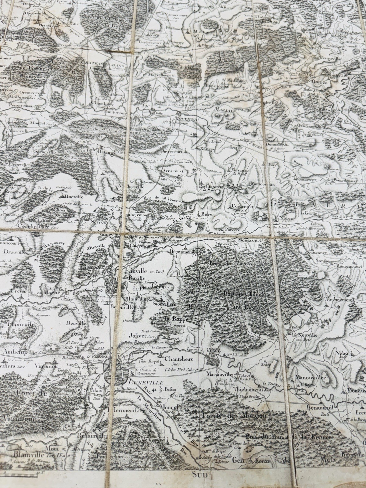
Rare and visually striking 18th-century folding map of the Nancy region in northeastern France, engraved by B. Desfontaines and published by Chez Vignon, a known Parisian dealer of geographic maps (“marchand de cartes de géographie”) located on rue Dauphine. This meticulously detailed map is mounted on linen and folds neatly into its original textured case with a handwritten title label marked “Nancy No. 142.” The map features intricate topographic detail, including forests, towns, rivers, and elevation changes. Notable is the rich density of information and precise engraving, typical of Enlightenment-era cartographic craftsmanship. The scale is listed as 1:40,000, and the engraver's name appears at the lower left. Key Details: Region Depicted: Nancy and surrounding areas in Lorraine, France Publisher: Chez Vignon, Paris Engraver: B. Desfontaines Date: Likely mid to late 1700s (based on style and publisher) Presentation: Linen-backed, folding map in original cloth case Dimensions (unfolded): Approx. 36" wide x 22" tall Condition: Some staining, fold wear, and age toning. Linen backing intact. Labels affixed to outer case with period ink notations. This is an extraordinary historical piece for collectors of antique French cartography, pre-Revolutionary mapping, or 18th-century European ephemera. A fine example of practical military or travel cartography from the Age of Reason.Thank you for visiting our listing!Fast shipping! We ship quickly once payment is received.Your item will be packed securely and shipped with care.Returns are accepted within 30 days - include a valid tracking number.Feel free to reach out with any questions or concerns. We're happy to help!


![National Geographic Reference Map - Italy Classic [Folded] (23" X 34" unfolded)](https://i.ebayimg.com/images/g/tKIAAOSw0PFnnZ1c/s-l225.jpg)