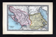
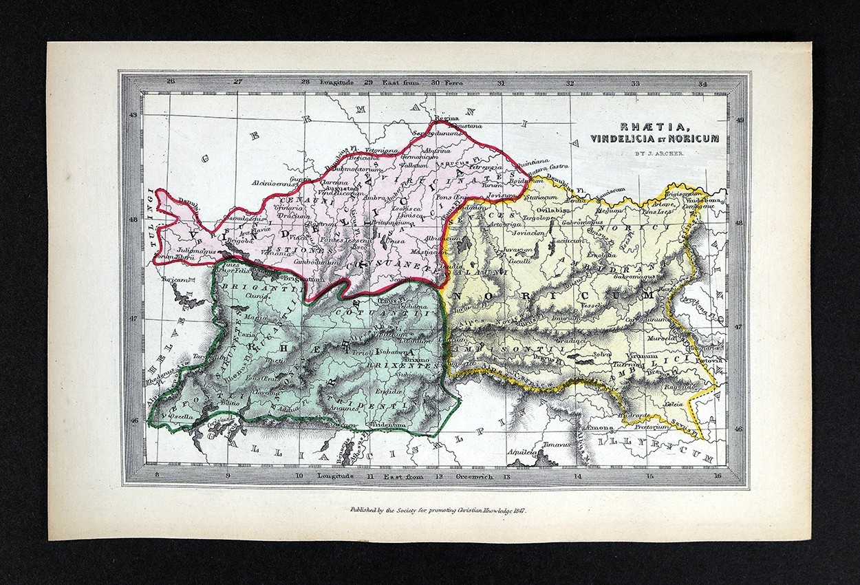
1847 SPCK J. Archer Antique Map of Rhaetia, Vindelicia & Noricum
This 1847 antique map page, published by the Society for Promoting Christian Knowledge (SPCK) and designed by J. Archer, depicts the ancient regions of Rhaetia, Vindelicia, and Noricum (covering areas of present-day Austria, Switzerland, and Bavaria). Condition is described as a rare antique map page; please review the photos and listing notes for details on wear, toning, or marks. The full page measures approximately 4 1/2 x 6 3/4 inches (11 x 17 cm). Free shipping is included—check the listing for dispatch and delivery details.


| Location | Fairview US |
| Shipping | Free shipping (check listing for details) |
| Seller |
c574778
99.8% positive · 16761 feedback
|
| Listing | FixedPrice · Active |
| Start time | 2025-12-07T07:09:18.000Z |
| Date Range | 1800-1899 |
| Type | Thematic Map |
| Format | Atlas Map |
| Printing Technique | Copper Plate |
| Year | 1847 |
| Original/Reproduction | Antique Original |
| Cartographer/Publisher | J. Archer |
| Country/Region | Austria, Germany, Switzerland |
| Country of Origin | United Kingdom |
Lake Erie Maps & PrintsAn Original Antique Map: Not a Reproduction! Free US Shipping on Purchases of 5 or More Maps and PrintsDescription: It is an authentic antique map approximately 179 years old with original hand coloring, blank on reverse as issued. It was "Published by the Society for Promoting Christian Knowledge (SPCK), 1847," as stated in the bottom margin and was designed by J. Archer as stated in small print on the map. Printed in London, a copy of the title page is included, see the pic. It is not matted nor framed being sold as a single sheet as shown in the main pic. Overall, a nicely designed and rare miniature antique map with strong original
color that would frame up beautifully!Size: The image area measures approximately 3 1/2 by 5 3/4 inches (9x14cm) on a page measuring 4 1/2 by 6 3/4" (11x17cm). Condition: The map is in Very Good to Excellent condition, blank on reverse with original hand coloring as issued, very clean with strong
color on a bright heavy page, see the pic for more on condition. The pics are of the actual map.Save on Shipping: We only charge one shipping fee based on the largest map or print with multiple items shipped along with it for no extra costs. Purchase 5 or more maps or prints and receive Free First Class shipping in USA.International Customs and VAT Fees: It is the responsibility of the buyer to pay all Customs Taxes, VAT or other fees that may be due upon arrival. These fees vary greatly from country to country and ebay policy is that the buyer is responsible for their country's taxes and fees. Please consult your country's Customs Regulations for more details on your country, printed matter is duty free in many countries. We declare the full purchase value as required by law. Delays by Customs: Although most items arrive at their destination very quickly, we have no control over how long it takes an item to move through Customs, which can be held for up to six weeks in rare cases.Satisfaction Guaranteed: We stand fully behind our products and offer a full refund minus shipping with no questions asked.